http://www8.garmin.com/support/download_details.jsp?id=4435多語言版本的Basecamp已經推出了! 愛用者別錯過.
Changes made from version 3.0.4 to 3.0.5:
Added localization for the following languages: Chinese (Traditional), Croatian, Czech, Danish, Dutch, Finnish, French, German, Hungarian, Italian, Japanese, Norwegian (Bokmal), Polish, Russian, Slovak, Slovenian, Spanish, Swedish
Added the ability to unlock BirdsEye Imagery for a specific device.
Added support to recognize European Topographic cards as retail products.
Improved map projection when printing BirdsEye Imagery.
Change to preserve subfolders when writing Garmin Custom Maps.
Change to correctly resolve relative paths in links on waypoints received from devices.
Change to use a more reasonable zoom level when selecting 'Show on map' for a single find result or waypoint.
Change to update the database to reflect missing images when doing a 'Restore' when the images were excluded from the backed up.
Change to preserve selection of device when starting BirdsEye wizard, if a device was previously selected.
Change to read maps on SD cards written to the \Map subfolder.
Fixed auto-routing issues on certain maps.
Fixed copy/paste of geotagged photos from a device not copying the photo.
Fixed possible issues when launching an external file or URL link.
Fixed issues when reading geotagged photos with invalid timestamps.
Fixed displaying postal code twice in POI property balloons in some European maps.
Fixed issues geotagging photos with Asian language paths.

實用性都大大的增加
還有一個很棒的功能
可以直接讀取記憶卡中的圖資顯示於BaseCamp

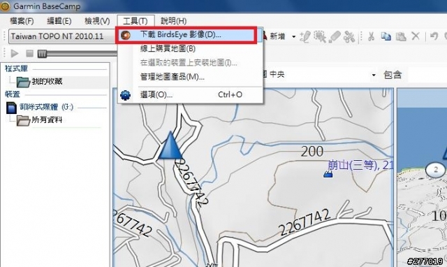
其中下載BirdsEye影像
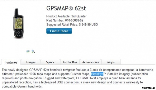
GPSMap 62st有支援

Timber Wolf wrote:
其中下載BirdsEye影像
GPSMap 62st有支援...(恕刪)
可惜台灣也不開放鳥眼衛星圖下載, 此外, 該圖的台灣區域是否全部都是高解析度的? 像Google Earth中還有部分地區呈現模糊的情形.
Garmin是這樣宣稱的: High-resolution sub-meter color satellite imagery captures the world in brilliant clarity and detail. 真希望台灣Garmin出幾張圖來與Google Earth比較比較.
millerliu wrote:
可惜台灣也不開放鳥眼衛星圖下載, 此外, 該圖的台灣區域是否全部都是高解析度的? 像Google Earth中還有部分地區呈現模糊的情形.
Garmin是這樣宣稱的: High-resolution sub-meter color satellite imagery captures the world in brilliant clarity and detail. 真希望台灣Garmin出幾張圖來與Google Earth比較比較.
這就不清楚了
不過依據官網上的敘述
是必須購買下載
而且是綁機器
當機器連結BaseCamp時
便會判斷機台ID是否給已付費使用權的機器使用
剛剛看了一下
不止GPSMap 62st
新一代的戶外機全部支援BirdsEye


內文搜尋
X