• 3

[分享] 雙星定位(GPS+GLONASS)的小鋼炮 Garmin eTrex 20

NGS benchmark HT2440

NAD83 UTM: 10S 0582281 4158025 Elev.: 32.29 ft.


Result:

1. GPS + GLONASS, WASS on

10S 0582281 4158024 Elev.: 24 ft.


2. GPS, WASS on (but didn’t get lock on WASS)

10S 0582282 4158028 Elev.: 30 ft.
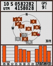


3. GPS , WASS off

10S 0582280 4158027 Elev.: 33 ft.


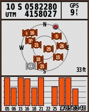
4. GPS + GLONASS, WASS off

10S 0582282 4158028 Elev.: 35 ft.


jaschiu wrote:
NGS benchm...(恕刪)


WAAS lock on需要若干時間, 目前看來只要lock on基本上有了差分資料都能縮小誤差距離, case 2就是如此, 不妨集中經歷觀察GPS+GLONASS(w/o WAAS)的實際誤差.
我要62st啦...
60 系統收訊比較強囉~~

美規的可以裝台灣TOPO地圖嗎???
eTrex 20 vs. Colorado 300 vs. Oregon 200

AE4373* NAD 83(1992)- 37 31 49.50235(N) 122 04 16.82037(W) ADJUSTED
AE4373* NAD 83(1992)- 10S 0582052 4154121
AE4373* NAVD 88 - 47.3 (meters) 155. (feet) VERTCON

eTrex 20 (FW: 2.50 GPS: 2.32)


GPS+GLONASS (WASS on)
10S 0582050 4154122 / 140 ft. / 水平誤差: 2.2 m 垂直誤差: 4.3 m


GPS (WASS on)
10S 0582050 4154122 / 134 ft. / 水平誤差: 2.2 m 垂直誤差: 6.4 m


GPS (WASS off)
10S 0582051 4154122 / 135 ft. / 水平誤差: 1.4 m 垂直誤差: 6.1 m


GPS+GLONASS (WASS off)
10S 0582050 4154122 / 139 ft. / 水平誤差: 2.2 m 垂直誤差: 4.9 m

Colorado 300 (FW: 3.70 GPS 2.90)


GPS (WASS on)
10S 0582052 4154121 / 144 ft. / 水平誤差: 0 m 垂直誤差: 3.4 m


GPS (WASS off)
10S 0582052 4154121 / 144 ft. / 水平誤差: 0 m 垂直誤差: 3.4 m

Oregon 200 (FW: 4.20 GPS: 5.00)


GPS (WASS on)
10S 0582050 4154122 / 131 ft. / 水平誤差: 2.2 m 垂直誤差: 7.3 m


GPS (WASS off)
10S 0582050 4154122 / 132 ft. / 水平誤差: 2.2 m 垂直誤差: 7.0 m
Garmin 發表 eTrex 20/30 FW Ver. 2.60

Changes made from version 2.50 to 2.60:
Added Geocaching with Photos (http://garmin.blogs.com/softwareupdates/2012/01/geocaching-with-photos.html)
Fixed potential naming issues with imported routes from BaseCamp
Fixed issue with reviewing BlueChart® g2 depth points from the map page
Fixed issue with magnetic north offset when projecting a waypoint

http://www8.garmin.com/support/download_details.jsp?id=5553
經過幾次測試的結果顯示,

在戶外開闊地形下,
GPS+WASS的精確度最高, GPS+GLONASS的精確度與GPS(無WASS)的精確度相當.

在困難地形下(如室內或高樓大廈間),
由於GPS+GLONASS可接收的衛星數較多, 往往可以有效改進GPS可達到的精確度.


GPS在室內的精確度.


GPS+GLONASS在室內的精確度.

電力測試 (官方宣稱25小時):
將eTrex20置於窗前, backlight off, track log on, Sony CycleEnergy AA (2000 mAh)

1. GPS + GLONASS (WASS off): 電力持續 23:37, 漂移 0.8 km.


2. GPS (WASS on): 電力持續 27:34, 漂移1.3 km.

Garmin 發表 eTrex 20/30 FW Ver. 2.80

Changes made from version 2.70 to 2.80:
Added ability to sort waypoints alphabetically
Improved GPS response at low speeds
Improved ability to clear unit settings on power up: now only requires menu key and enter key to be held when powering the unit on
Improved size of roads drawn on map in 'automotive mode' orientation
Improved elevation data stored in track logs (etrex 30)
Fixed issue that was causing some devices to display a 'memory full' message followed by bad device behavior
Fixed issue with distance to destination data field
Fixed occasional overlapping of data fields in the elevation application
Fixed issue where waypoints and geocaches could be lost

GPS Version 4.14
jaschiu wrote:
Garmin USA...(恕刪)

http://gpsinformation.info/penrod/etrex30/etrex30.html
看到這段好消息:
A major improvement is that the unit is all in a hard plastic case, without the rubber seal, which often had trouble becoming loose, especially if the unit was left in the sun.

eTrex Vista HCx周圍的橡膠圈總是像塗了油似的, 永遠都無法固定, 既使送修數次更換還是一樣, 希望這次改進真的徹底解決了這bug.


http://gpstracklog.com/2011/10/garmin-etrex-30-review.html
看到電池的實際使用時間:
With the backlight set to remain on full, batteries lasted 10 hours and 17 minutes. With the backlight off, the eTrex 20 ran for an amazing 23 hours and 29 minutes before shutting off.

millerliu wrote:
http://gps...(恕刪)


eTrex 20的確蠻省電的(不知是否使用手機等級的GPS晶片組?), 可惜地圖顯示速度有點慢.
  • 3
內文搜尋
X
評分
評分
複製連結
Mobile01提醒您
您目前瀏覽的是行動版網頁
是否切換到電腦版網頁呢?